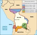
चित्र:Map Bolivia territorial loss-en.svg

पूर्वावलोकन PNG का आकार SVG फ़ाइल: ३७५ × ३५५ पिक्सेल दूसरे रेसोल्यूशन्स: २५४ × २४० पिक्सेल | ५०७ × ४८० पिक्सेल | ८११ × ७६८ पिक्सेल | १,०८२ × १,०२४ पिक्सेल | २,१६३ × २,०४८ पिक्सेल।
मूल चित्र (SVG फ़ाइल, साधारणतः ३७५ × ३५५ पिक्सेल, फ़ाइल का आकार: ७८ KB)
चित्र का इतिहास
चित्र पुराने समय में कैसी दिखती थी यह जानने के लिए दिनांक/समय पर क्लिक करें।
| दिनांक/समय | थंबनेल | आकार | सदस्य | टिप्पणी | |
|---|---|---|---|---|---|
| वर्तमान | २१:४९, १ जनवरी २०२० |  | ३७५ × ३५५ (७८ KB) | Janitoalevic | Added territory ceded to Argentina |
| ००:१८, १३ दिसम्बर २०१३ |  | ३७५ × ३५५ (६८ KB) | Pethrus | Fixed ocean name | |
| २१:३७, ४ मई २०१० |  | ३७५ × ३५५ (६८ KB) | Naturals | The territory of Paraguay was reversed with the territory of Brazil | |
| ००:३६, ४ मई २०१० |  | ३७५ × ३५५ (६९ KB) | Pethrus | Paraguay border fixed | |
| ००:३२, ४ मई २०१० |  | ३७५ × ३५५ (६९ KB) | Pethrus | Fixed bugs | |
| ००:२६, ४ मई २०१० |  | ३७५ × ३५५ (७९ KB) | Pethrus | Inkscape bugs fixed | |
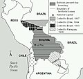
| ००:२३, ४ मई २०१० |  | ३७५ × ३५५ (८१ KB) | Pethrus | {{Information |Description={{en|Territorial loss map of Bolivia}} |Source=*File:Bolivia_territorial_loss_map_LOC.jpg |Date=2010-05-03 18:51 (UTC) |Author=*File:Bolivia_territorial_loss_map_LOC.jpg: Library of Congress Country Study on Bolivia |
चित्र का उपयोग
यह पृष्ठ इस चित्र का इस्तेमाल करता है:
चित्र का वैश्विक उपयोग
इस चित्र का उपयोग इन दूसरे विकियों में किया जाता है:
- az.wikipedia.org पर उपयोग
- ca.wikipedia.org पर उपयोग
- cs.wikipedia.org पर उपयोग
- da.wikipedia.org पर उपयोग
- de.wikipedia.org पर उपयोग
- en.wikipedia.org पर उपयोग
- eu.wikipedia.org पर उपयोग
- fi.wikipedia.org पर उपयोग
- fr.wikipedia.org पर उपयोग
- hi.wikipedia.org पर उपयोग
- id.wikipedia.org पर उपयोग
- it.wikipedia.org पर उपयोग
- ja.wikipedia.org पर उपयोग
- ka.wikipedia.org पर उपयोग
- ko.wikipedia.org पर उपयोग
- lt.wikipedia.org पर उपयोग
- nl.wikipedia.org पर उपयोग
- pl.wikipedia.org पर उपयोग
- pt.wikipedia.org पर उपयोग
- sat.wikipedia.org पर उपयोग
- sd.wikipedia.org पर उपयोग
- sk.wikipedia.org पर उपयोग
- te.wikipedia.org पर उपयोग
- zh.wikipedia.org पर उपयोग


