
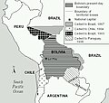
चित्र:Map Bolivia territorial loss-en.jpg

इससे बड़ा रेसोल्यूशन उपलब्ध नहीं हैं।
Map_Bolivia_territorial_loss-en.jpg (४७१ × ४४७ चित्रतत्व, संचिका का आकार: ५६ KB, माइम प्रकार: image/jpeg)

|
File:Map Bolivia territorial loss-en.svg is a vector version of this file. It should be used in place of this JPG file when not inferior.
File:Map Bolivia territorial loss-en.jpg → File:Map Bolivia territorial loss-en.svg
For more information, see Help:SVG. |
 |
सारांश
Taken from PDF file: http://lcweb2.loc.gov/frd/cs/bolivia/bo01_05a.pdf Converted by uploader The file is part of the Library of Congress Country Study on Bolivia
Other versions: []
-
 English (JPEG original)
 -
 English
 -
 español
 -
 français
 -
 magyar
 -
 македонски
 -
 српски / srpski


लाइसेंस
This work is in the public domain in the United States because it is a work prepared by an officer or employee of the United States Government as part of that person’s official duties under the terms of Title 17, Chapter 1, Section 105 of the US Code.
Note: This only applies to original works of the Federal Government and not to the work of any individual U.S. state, territory, commonwealth, county, municipality, or any other subdivision. This template also does not apply to postage stamp designs published by the United States Postal Service since 1978. (See § 313.6(C)(1) of Compendium of U.S. Copyright Office Practices). It also does not apply to certain US coins; see The US Mint Terms of Use.
|
 | |
| इस फ़ाइल को कॉपीराइट कानूनों के अंतर्गत सभी संबंधित अधिकारों समेत ज्ञात सीमाओं से मुक्त पहचाना गया है। | ||
derivative works
Derivative works of this file: Map Bolivia territorial loss-en.svg
चित्र का इतिहास
चित्र पुराने समय में कैसी दिखती थी यह जानने के लिए दिनांक/समय पर क्लिक करें।
| दिनांक/समय | थंबनेल | आकार | सदस्य | टिप्पणी | |
|---|---|---|---|---|---|
| वर्तमान | ०३:४०, २५ जनवरी २००६ | | ४७१ × ४४७ (५६ KB) | Bkwillwm | Category:Maps of Bolivia Category:LOC Wikiproject Taken from PDF file: http://lcweb2.loc.gov/frd/cs/bolivia/bo01_05a.pdf Converted by uploader The file is part of the Library of Congress Country Study on Bolivia |
चित्र का उपयोग
कोई भी ऐसा पृष्ठ नहीं है जो इस चित्र का प्रयोग कर रहा हो।
चित्र का वैश्विक उपयोग
इस चित्र का उपयोग इन दूसरे विकियों में किया जाता है:
- en.wikibooks.org पर उपयोग
- es.wikipedia.org पर उपयोग
- fr.wikipedia.org पर उपयोग